
Cambodia Hopes UNCLOS Will Deliver Koh Kood, But It Miscalculated!
When examining sovereignty and maritime rights through the lens of the United Nations Convention on the Law of the Sea (UNCLOS)—setting aside political rhetoric—it becomes clear that Thailand's maritime boundary delimitation is legally sound, precise, and fully compliant with international standards.
---
1. 1972 Cambodian Claim Line vs. 1973 Thai Claim Line: Which Line Aligns with UNCLOS?
The maritime claims in the Gulf of Thailand made by both nations stem from fundamentally different legal principles and baselines:
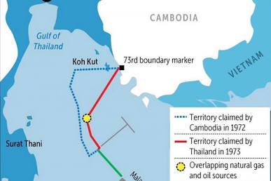
Comparison of the 1972 Cambodian and 1973 Thai claim lines
---
Koh Kood is Thai territory both de jure and de facto. It is permanently inhabited by a local population, houses official government facilities, and its sovereignty has been continuously exercised and recognized since the Franco-Siamese Treaty of 1907 without a single dispute. Therefore, the calculation of the Exclusive Economic Zone (EEZ) must be measured outward from Koh Kood as a baseline, rather than being arbitrarily severed by a straight line drawn across the island.
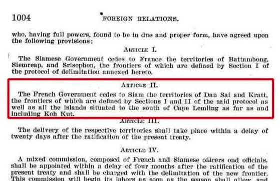
The 1907 Franco-Siamese Treaty specifying that Siam's (Thailand's) territory includes Koh Kood
2. Border Land Reclamation: Why "Artificial Islands" Generate No Maritime Claims
Concerns regarding Cambodian land reclamation and construction extending into coastal areas near the border in an attempt to project maritime jurisdiction are entirely without legal foundation under international law.
According to the provisions of UNCLOS:
"A naturally formed island entitled to its own territorial sea, contiguous zone, or exclusive economic zone (EEZ) must be an area of land above water at high tide capable of sustaining human habitation or an economic life of its own."
This means that man-made structures, land reclamation projects, or reclaimed features are classified strictly as "artificial islands" or marine installations. UNCLOS explicitly dictates that artificial islands do not possess the status of islands and have no territorial sea or EEZ of their own—not even a single square meter.
Although past border friction led Thailand to protest these activities—resulting in minor dismantling while leaving some structures intact (perhaps under a mistaken belief that they could serve as baseline points in the future)—such actions stem from a misinterpretation or incomplete reading of UNCLOS. Regardless of the scale of land reclamation or remaining structures, international law strictly prohibits using artificial features as sovereign baselines.
Furthermore, reclamation or coastal construction that alters sea currents and sediment dynamics to the detriment of a neighboring country's marine ecosystem and coastline violates international obligations to protect the marine environment. Thailand retains full rights under international mechanisms to demand the complete removal of such structures.
---
3. Key Concepts: Maritime Zones Under UNCLOS
1. Internal Waters: Waters on the landward side of the baseline, over which the coastal state exercises complete sovereignty.
2. Territorial Sea: Extends up to 12 nautical miles (approx. 22.22 km) from the baseline, which in this case must be measured outward from Koh Kood.
3. Contiguous Zone: Extends up to 24 nautical miles (approx. 44.44 km) from the baseline for the enforcement of customs, fiscal, sanitary, and immigration laws.
4. Exclusive Economic Zone (EEZ): Extends up to 200 nautical miles (approx. 370.40 km) from the baseline, granting the coastal state sovereign rights to explore, exploit, conserve, and manage natural resources.
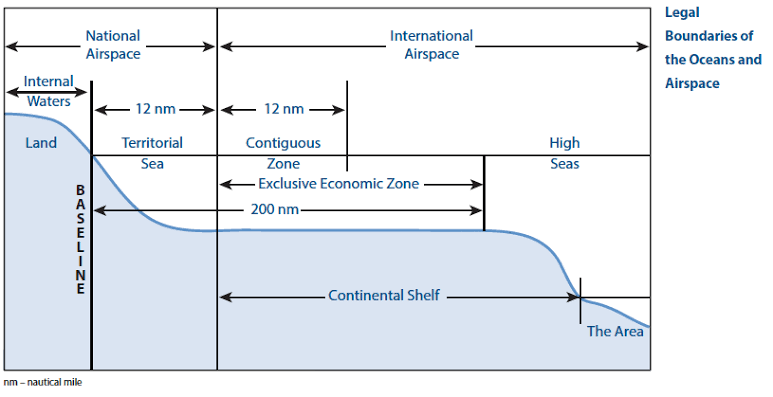
Various maritime zones according to UNCLOS principles. Source: Tufts University
---
Conclusion
---